Research
Bikini Atoll
Marshall Islands
Class VIII - Environmental Condition, Nuclear Testing
![]()
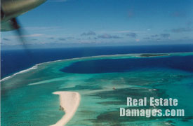 |
Bikini Atoll - Bravo Crater |
Early in the morning on March 1, 1954, the hydrogen bomb "Bravo" was detonated on the surface of the reef in the northwestern corner of Bikini Atoll. A huge expanding flash of blinding light illuminated the region. A raging fireball of heat that measured into the millions of degrees shot skyward at a rate of 300 miles an hour. Within minutes the enormous clouds, filled with nuclear debris, shot up more than 20 miles and generated winds measured to be hundreds of miles per hour.
The military believed that the blast would only carry a payload of approximately 3 megatons, yet it actually yielded 15 megatons, which was a thousand times more powerful than the Fat Man and Little Boy atomic bombs dropped on Nagasaki and Hiroshima. The blast vaporized the island and reef, while creating a mile-wide crater that was 400 feet deep. For reasons never explained, the bomb was detonated even through the prevailing winds had changed and were blowing towards inhabited islands.
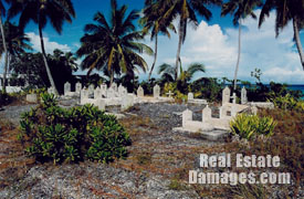 |
Cemetery - Marshall Islands |
The radioactive fallout fell over a hundred miles to the east on the inhabited atolls of Rongelap, Rongerik, Ailinginae, and Utrik. Many became sick and some died. Recently declassified documents show that some scientist were enthusiastic about the "opportunity" to study the effects of radioactive exposure on humans. Much of the contaminated areas are still radioactive today.
Some highly radioactive areas have had the soils scraped, some have been covered by gravel, and potassium has been spread in some areas to prevent the plant life from absorbing the radioactive Cesium. Slowly, some of the islands are being resettled by the original inhabitants.
<<Return to Research Page